
10 Day New England Fall Foliage Road Trip + Free Google Sheets Template
Matt - August 24, 2026
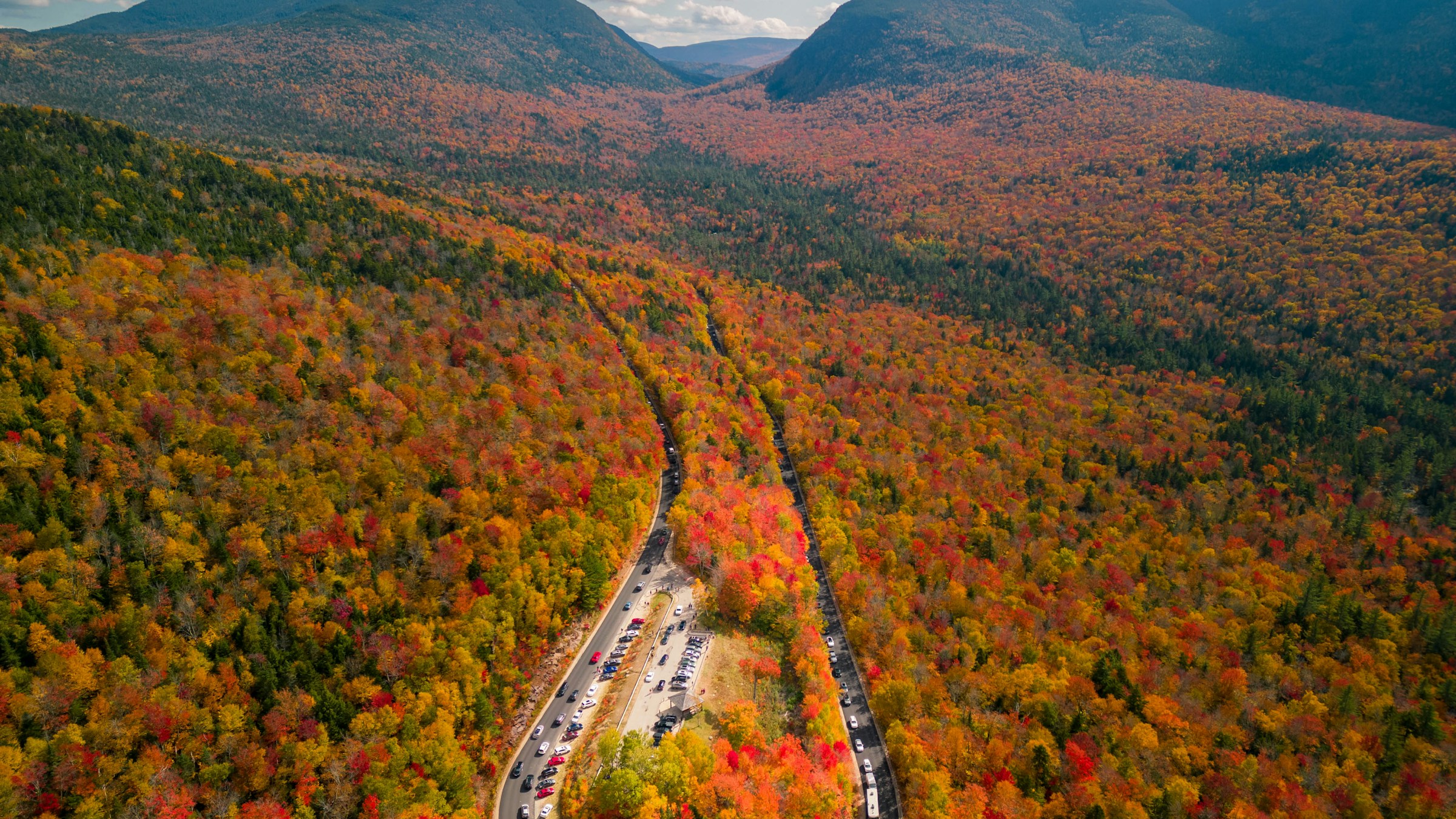
Ten days gives you enough time to combine New England's mountain roads, small towns, coastal cities, and Acadia National Park in one fall trip. This itinerary begins in Boston, continues through Woodstock and Stowe in Vermont, crosses the White Mountains in New Hampshire, and follows the Maine coast from Portland to Bar Harbor.
The sample dates run from October 1 through October 10, a useful starting point for a trip that moves from inland mountain areas toward the coast. Fall color changes each year and varies by elevation, so check the current foliage reports for Vermont, New Hampshire, and Maine as your trip approaches.
You can use the free 10 Day New England Fall Foliage Road Trip Google Sheets template as the itinerary for your own trip. It includes the day-by-day plan, specific locations, lodging bases, driving notes, official links, optional ideas, packing items, pre-trip tasks, costs, and sample cost-splitting rows.

Itinerary Outline
- Day 1: Arrive in Boston and explore the Freedom Trail and North End
- Day 2: Drive to Woodstock and Quechee, then continue to Stowe
- Day 3: Waterfalls, mountain scenery, and Stowe
- Day 4: Franconia Notch and the Kancamagus Highway to North Conway
- Day 5: Crawford Notch and the Mount Washington area
- Day 6: Drive to Portland and visit Portland Head Light
- Day 7: Explore Portland and Casco Bay
- Day 8: Stop in Camden, then continue to Bar Harbor
- Day 9: Acadia National Park's Park Loop Road
- Day 10: Cadillac Mountain, Jordan Pond, and departure from Bangor
The route uses five lodging bases: Boston, Stowe, North Conway, Portland, and Bar Harbor. An open-jaw flight into Boston and out of Bangor keeps the final day manageable. Travelers with round-trip Boston flights can add a night for the drive back from Bar Harbor.
Best time and pacing for a New England fall road trip
Late September through mid-October is the main planning window for fall color across this route. Higher elevations and northern areas often change first, followed by lower valleys and the Maine coast. A ten-day trip can include several stages of the season, especially when it moves from Vermont and the White Mountains toward Portland and Acadia.
Use the Vermont fall foliage report and New Hampshire foliage tracker to compare current conditions. Maine's tourism office also publishes seasonal foliage updates. These reports are more useful close to departure than a fixed peak-date prediction made months ahead.
Mountain weather can change quickly in October. A clear day is valuable for Mount Mansfield, the Kancamagus Highway overlooks, Crawford Notch, and Cadillac Mountain. Keep one or two scenic activities flexible within each lodging base so you can use the best available conditions.
Driving times on mountain and coastal roads also expand during foliage season. Viewpoints, short walks, town centers, and lunch stops are part of the day, and traffic can build around the most popular scenic roads. This itinerary keeps most stays to two nights so each base includes time away from the car.
Day 1: Boston, the Freedom Trail, and the North End
Collect the rental car at Boston Logan International Airport or wait until the next morning if your hotel charges heavily for parking. A hotel near Boston Common, the North End, or the waterfront gives you a convenient first-day base.
Begin at Boston Common and follow part of the Freedom Trail. The marked route links 16 historic sites, including the Massachusetts State House, Granary Burying Ground, Old South Meeting House, Faneuil Hall, Paul Revere House, and Old North Church. You can walk the central section in a few hours or continue across the Charlestown Bridge to the USS Constitution and Bunker Hill Monument.
Beacon Hill is close to Boston Common and is known for brick sidewalks, Federal-style rowhouses, gas lamps, and small neighborhood streets. Acorn Street is the familiar postcard view, while Charles Street has cafés, shops, and easy access to the Charles River Esplanade.
Spend the evening in the North End. Hanover and Salem streets are lined with Italian restaurants, bakeries, cafés, and historic buildings. Reservations are useful for a specific dinner choice, especially on a fall weekend.
Day 2: Woodstock, Quechee Gorge, and Stowe
Leave Boston in the morning and drive northwest to Woodstock, Vermont. The village center has covered bridges, historic homes, independent shops, and a compact green that is easy to explore on foot. Middle Covered Bridge crosses the Ottauquechee River close to the center, while Billings Park has short wooded trails above town.
Continue to Quechee Gorge, where the Ottauquechee River cuts through a steep, forested channel. The bridge on Route 4 provides the main overlook, and trails descend toward the river when conditions and current access allow. Nearby Quechee village has a covered bridge, mill buildings, and places for lunch or local food shopping.
Drive north to Stowe in the afternoon. Main Street sits beneath the white steeple of Stowe Community Church, with shops, galleries, cafés, and restaurants stretching through the village. Stay near the village for walkable evenings or along Mountain Road for easier access to Mount Mansfield and Smugglers' Notch.
Day 3: Moss Glen Falls, Mount Mansfield, and Stowe
Start at Moss Glen Falls, a tall roadside waterfall north of Stowe. The lower viewpoint is reached by a short walk, and the surrounding forest can be especially colorful in early October. Morning light and an early arrival make the stop more pleasant during the busy fall season.
Continue toward Mount Mansfield, Vermont's highest peak. The Stowe gondola provides mountain views and access to high-elevation trails when it is operating. Another option is the Auto Toll Road, which climbs toward the ridge from the resort side. Check current dates, weather, and operating status directly with Stowe Mountain Resort before choosing either activity.
Route 108 through Smugglers' Notch passes between steep rock walls and forested slopes. Pull-offs are limited, and the road is narrow and winding, so allow time for traffic and follow seasonal closure information. The area has short walks among large boulders as well as longer trails for experienced hikers.
Return to Stowe for the Recreation Path, which follows the West Branch Little River past fields, covered bridges, and mountain views. Finish with dinner in the village or along Mountain Road.

Day 4: Franconia Notch and the Kancamagus Highway
Drive east from Stowe into New Hampshire and enter Franconia Notch State Park. The Flume Gorge trail follows boardwalks through a granite chasm with waterfalls, covered bridges, and forest views. Reserve an entrance time during the fall season and check current trail conditions with New Hampshire State Parks.
Nearby stops include the Basin, a smooth granite pothole formed by the Pemigewasset River, and Echo Lake, which sits beneath the cliffs of Cannon Mountain. Cannon's aerial tramway and the Old Man of the Mountain memorial area are additional choices according to seasonal operations and weather.
Continue along the Kancamagus Highway, a 34-mile section of Route 112 through the White Mountain National Forest. The road has overlooks across the Swift River valley and access to short walks such as Sabbaday Falls, Rocky Gorge, and Lower Falls. Stop at the viewpoints that match the day's light and foliage conditions.
Stay in North Conway, which has a walkable village center, restaurants, outdoor shops, and convenient access to both the Kancamagus Highway and Crawford Notch.
Day 5: Crawford Notch and Mount Washington
Follow Route 302 into Crawford Notch State Park. The road passes between steep mountain slopes, historic railroad structures, waterfalls, and trailheads. The Willey House site tells the story of the 1826 landslide that shaped local history, and nearby walks offer views into the notch.
At the north end of the notch, the Mount Washington Cog Railway climbs the western side of the Northeast's highest peak. The journey crosses open mountain terrain and reaches an alpine summit where conditions can be much colder and windier than in the valley. Reserve ahead and check the day's operating plan and summit forecast through the Mount Washington Cog Railway.
Travelers who prefer a drive can check the Mount Washington Auto Road's current schedule and weather status. The summit museum and observation areas add context on the mountain's weather, geology, and transportation history when they are open.
Return to North Conway through the Mount Washington Valley. Jackson's covered bridge and village, Bartlett, and the Conway Scenic Railroad are useful additions according to the time available.
Day 6: Portland Head Light and Portland
Drive from North Conway to the Maine coast. Portland Head Light stands at the entrance to Casco Bay within Fort Williams Park in Cape Elizabeth. The lighthouse dates to the late 18th century, and the park's paths open to rocky shoreline, historic fort remains, picnic areas, and broad ocean views.
Continue into Portland and stay around the Old Port, Arts District, or East End. The Old Port is known for brick warehouses, cobbled streets, working-waterfront views, restaurants, and independent shops. The East End provides access to the Eastern Promenade and Casco Bay, while the Arts District is convenient for museums and Congress Street.
Walk the Old Port and Commercial Street in the afternoon. The working waterfront includes fishing wharves, ferry terminals, seafood businesses, and views across the harbor. Choose dinner based on the style of Maine seafood you want to try, from a casual lobster roll to oysters or a longer restaurant meal.

Day 7: Portland neighborhoods and Casco Bay
Begin at the Eastern Promenade, a hillside park overlooking Casco Bay and the Calendar Islands. The paved trail follows the waterfront toward the Old Port and works well for a morning walk before museums and shops open.
Visit the Portland Museum of Art for American, European, and contemporary art, including work connected to Maine. Food-focused travelers can explore the shops and markets around the Old Port, while history-focused visitors can tour the Wadsworth-Longfellow House when it is open.
A Casco Bay ferry adds time on the water and a different view of Portland's harbor. Peaks Island is the easiest island outing, with a village, shoreline roads, and bicycle rentals. The ferry schedule changes seasonally, so choose the sailing before building the rest of the day.
Back in the city, walk Munjoy Hill, browse Exchange and Fore streets, or spend more time around the waterfront. Portland supports a full second evening of dining, breweries, bakeries, and small food businesses.
Day 8: Camden and Bar Harbor
Leave Portland and follow the Maine coast toward Camden. The harbor sits beneath wooded hills and is filled with sailboats, schooners, and working vessels. Camden's center has restaurants, galleries, bookstores, and a public landing overlooking the water.
For a higher view, drive into Camden Hills State Park and follow the road toward Mount Battie when it is open. The overlooks take in Camden Harbor, Penobscot Bay, and the islands beyond. Hiking trails also reach Mount Battie and Mount Megunticook from the park.
Continue to Bar Harbor in the afternoon. The Shore Path begins near the town pier and follows the edge of Frenchman Bay past rocky shoreline and historic properties. Bar Harbor's compact center has restaurants, shops, galleries, and easy access to Acadia National Park.

Day 9: Acadia National Park's Park Loop Road
Enter Acadia early and follow the Park Loop Road through the eastern side of Mount Desert Island. Sand Beach is a small cove framed by granite headlands. The Ocean Path continues along the coast to Thunder Hole and Otter Point, with frequent views of cliffs, offshore islands, and Atlantic surf.
Thunder Hole is a natural inlet where waves can force air and water into a narrow channel. Conditions determine how dramatic the sound and spray will be. Farther south, Otter Cliff and Otter Point have broad coastal views and access to rocky shoreline.
Continue toward Jordan Pond, a clear glacial lake beneath the rounded peaks known as the Bubbles. The pond path makes a mostly level loop with sections of rocks and narrow boardwalk. Jordan Pond House is known for popovers and lawn views, and reservations can be useful during the fall season.
The carriage roads offer another way to see Acadia. These broken-stone roads pass forests, lakes, and granite bridges and are open to walking, cycling, and horse-drawn carriage use according to park rules and current conditions.

Day 10: Cadillac Mountain and departure from Bangor
Cadillac Mountain has wide views over Mount Desert Island, Frenchman Bay, and the Maine coast. Vehicle reservations are required for Cadillac Summit Road from May 20 through October 25 in 2026. The reservation is separate from the Acadia entrance pass, and the National Park Service releases reservation inventory on a rolling schedule.
Sunrise is popular, but morning and midday reservations also provide expansive views with a simpler start to departure day. Conditions can be cold and windy at the summit, even when Bar Harbor feels mild.
Use the rest of the morning for Jordan Pond, a short carriage-road walk, or time in Bar Harbor according to your flight. The drive to Bangor International Airport takes you inland from Mount Desert Island. Allow time for fuel, the rental-car return, and airline check-in.

Where to stay along the route
Boston
Boston Common and the Back Bay are convenient for the Freedom Trail, Beacon Hill, restaurants, and transit. The North End and waterfront are useful for harbor access and evening dining. Compare hotel parking with collecting the rental car on Day 2.
Stowe
Stowe village has a traditional town-center setting with walkable shops and restaurants. Mountain Road is better for quick access to Mount Mansfield, the Recreation Path, and Smugglers' Notch. Book early for fall weekends.
North Conway
North Conway is the practical base for the Kancamagus Highway, Crawford Notch, and Mount Washington. The village has restaurants and shops, while lodging north of town shortens the drive toward Crawford Notch.
Portland
The Old Port puts the waterfront, ferry terminal, restaurants, and shops within walking distance. The East End is quieter and close to the Eastern Promenade. Confirm overnight parking with the hotel.
Bar Harbor
Downtown Bar Harbor works well for restaurants, the Shore Path, and Island Explorer shuttle access. Lodging closer to Acadia entrances can make early park mornings easier. Fall operations vary, so confirm restaurant, shuttle, and activity schedules for your dates.
Driving and booking priorities
Reserve a one-way rental car from Boston Logan to Bangor International Airport. Compare the one-way fee, mileage rules, insurance, toll arrangements, fuel policy, and opening hours at the Bangor return location.
Book Stowe, North Conway, and Bar Harbor lodging first if you are traveling during the main foliage weeks. These bases have limited inventory compared with Boston and Portland. Reserve the Flume Gorge, Mount Washington Cog Railway, and any ferry or cruise that is important to the trip.
Acadia requires a park entrance pass, and Cadillac Summit Road requires a separate timed vehicle reservation during the reservation season. Review the current Acadia conditions and alerts before visiting.
Carry layers, rain protection, and comfortable shoes. October mornings can be cold in the mountains, while Portland and the Maine coast may feel milder. Download offline maps before driving through mountain areas with limited service.
Optional ideas for your New England itinerary
Add Shelburne Museum and Burlington for another Vermont day. Shelburne Museum brings together American art, historic buildings, folk art, carriages, and a steamboat across a large campus. Burlington adds Church Street, Lake Champlain, and a broader restaurant scene.
Add Conway Scenic Railroad for a rail journey through the Mount Washington Valley. Seasonal schedules and route lengths vary, making it a good North Conway option for travelers who want more scenery and less driving.
Add Kennebunkport or Ogunquit between North Conway and Portland for coastal villages, beaches, and the Marginal Way cliff walk. This works best with another night so Portland still has a full day.
Add Rockland near Camden for the Farnsworth Art Museum, which focuses on American art and has strong ties to Maine artists. Rockland's harbor and Main Street also make a useful lunch stop.
Add the Schoodic Peninsula for a quieter section of Acadia with rocky shoreline, spruce forest, and views across Frenchman Bay toward Mount Desert Island. Allow most of a day because it is reached by a separate drive from Bar Harbor.
What the New England Google Sheets itinerary template includes
- A scheduled Boston, Vermont, White Mountains, Portland, Camden, and Acadia itinerary
- Unscheduled ideas for museums, scenic roads, coastal towns, hikes, ferries, and trip extensions on the Itinerary tab
- Specific locations, official links, lodging notes, driving reminders, and booking details
- A packing list and pre-trip checklist tailored to fall weather, mountain drives, and Acadia
- Cost fields and sample split-cost rows for shared lodging, rental car, fuel, tolls, park fees, and activities
For a general planner you can adapt to any trip, see the free Google Sheets travel planner and itinerary template.
How Travel Mapper helps with a New England road trip
The Travel Mapper Google Sheets add-on adds map-based itinerary planning to Google Sheets. Seeing Boston, Vermont villages, White Mountain drives, Portland, Camden, Bar Harbor, lodging bases, and airports on the same map helps you review the geography of the trip while you fine-tune each day.
You can adjust the itinerary with drag-and-drop editing, use Google Maps autofill while adding places, email the itinerary, and export it to Google My Maps. The Travel Mapper Chrome extension can add a hotel, restaurant, attraction, trail, ferry, or scenic stop from a page you are researching.
If you want to review or edit the trip from your phone while traveling, the Travel Mapper web app works in a mobile browser.
The Google Sheets itinerary remains available for free. You can try the full Travel Mapper add-on feature set for seven days, then upgrade when you want to continue using the map view and other add-on tools.
New England fall road trip FAQ
Is 10 days enough for a New England fall foliage road trip?
Yes. Ten days supports two nights each in Stowe, North Conway, Portland, and Bar Harbor, plus the arrival night in Boston. Adding another night is useful for a round-trip Boston drive or a longer Acadia visit.
When is peak fall foliage in New England?
Peak color varies by year, elevation, latitude, and weather. Late September through mid-October is the broad planning window for this route. Check current state foliage reports close to departure and use the clearest days for mountain viewpoints.
Do I need a rental car for this itinerary?
Yes. A rental car is needed for the Vermont, New Hampshire, and Maine sections. You can collect it on arrival or on the morning you leave Boston. A one-way return at Bangor Airport fits the route best.
Where should I fly into and out of?
Fly into Boston Logan International Airport and out of Bangor International Airport for the most direct itinerary. Portland International Jetport is another departure option if you shorten the Maine section. Round-trip Boston flights usually need an extra travel day after Bar Harbor.
Do I need a reservation for Cadillac Mountain?
Yes, during the seasonal reservation period. In 2026, vehicle reservations are required for Cadillac Summit Road from May 20 through October 25. The reservation is separate from the Acadia park entrance pass.
Can I use the itinerary template for free?
Yes. Open the New England itinerary template, make a copy in Google Drive, and customize it for your dates and interests. The spreadsheet remains usable after the Travel Mapper add-on trial.
How do I see the itinerary on a map?
Install Travel Mapper from the Google Workspace Marketplace and open the map from the Extensions menu in Google Sheets. The add-on includes a seven-day trial of its full feature set.